| JGH::Docs.Politics.WardReview.DraftPER.Proposal.htm | Search |
This commentary considers each part of the city in the same order as the draft PER report. Each of the recommendations stand separately from each other and can be implemented independently. The electorate numbers and forecasts are those used in the draft PER report.
1.1 The PER draft recommends arranging this area into six new wards, provisionally named West Ecclesfield, East Ecclesfield, Parson Cross and Southey Green, Firth Park and Longley, Shiregreen and Brightside, and Burngreave.
1.2 The proposed boundary between West Ecclesfield and East Ecclesfield gives a better electoral fit and appears to match the communities better than my original submission. Being dependent on public transport it was difficult for me to return to the area more than a couple of times to inspect features on the ground. This arrangement has support from Ecclesfield Parish Council who probably know the area better than anybody else.
1.3 The rest of the wards arrange the rest of the area quite well electorally and geographically. Firth Park and Fir Vale shopping centres have each been reunified and most of Shirecliffe is in one ward, and Shiregreen is mostly in one ward.
1.4 The northernmost boundary between Parson Cross and Southey Green ward and Firth Park and Longley ward is proposed to run along the northernmost edge of the properties fronting onto Deerlands Avenue. Further to the east the stream Sheffield Lane Dike and Hartley Brooke Dike are used as a boundary. This is a clearly visible geographical feature on the ground. Sheffield Lane Dike should be used as the boundary north of Deerlands Avenue. Between Holgate Avenue and Barnsley Road, rather than the rear of the properties. This would result in the block of four houses at the north-east corner of Deerlands Avenue/Holgate Avenue junction not having a ward boundary running through them.
1.5 This would transfer two properties, approximately 3 electors, from Parson Cross and Southey Green ward to Firth Park and Longley ward, and is shown on Map A.
1.6 The PER draft proposal puts the area around Creswick Greave, Yew Greave Crescent and Yew Lane in Parson Cross and Southey Green ward. This area, particularly along Yew Lane, very much think of themselves as being part of Ecclesfield. I would recommend putting this area in Ecclesfield East ward. This can be done with a straight swap with the area west of Tunwell Avenue in Parson Cross and Southey Green ward.
1.7 I recommend using the boundary proposed in my original submission between "Ward 3" and "Ward 6", with the difference that Colley Road east of the burial ground near Holgate Road should remain in the PER's proposed East Ecclesfield ward.
1.8 The recommended boundary would then run as: center of Creswick Lane, rear of properties on south side of Yew Lane, center of Monteny Road, eastern edge of playing fields and recreation ground, between Wheata Drive and Tunwell Drive, between Wheata Road and Tunwell Drive, east of properties on Colley Crescent to the burial ground on Colley Road and thence to the PER proposed boundary along Sheffield Lane Dike. This is shown on Map A.
1.9 This would involve a net transfer of 1262 electors from the proposed East Ecclesfield ward to the proposed Parson Cross and Southey Green ward, and a net transfer of 774 electors in the other direction. This would result in the following electorates:
PER Draft Proposal:
2001 2006
Electorate: 10: East Ecclesfield 14193 +5% 14280 +5%
20: Parson Cross/Southey Gn 13709 +1% 13429 -1%
Recommendation:
2001 2006
Electorate: 10: East Ecclesfield 13705 +1% 13792 +1%
20: Parson Cross/Southey Gn 14197 +5% 13429 +2%
As can be seen, this reduces the 2006 electoral variances from +5%/-1% to +1%/+2%.
1: Adjustment to exact track of boundary along Sheffield Lane Dike, see Map A.
2: Swap Creswick Greave/Yew Lane area for Colley/Wheata area, see Map A.
2.1 The PER draft recommends arranging this area into three new wards, provisionally named Stocksbridge and Upper Don, Stannington, and Hillsborough.
2.2 The PER draft refers to Stocksbridge Town Council having four Town Council wards. I had previously been informed that the Town Council had arranged to split its East ward into two in due time for the 2003 Town Council elections. I have since clarified this, and this is not due to happen until after the 2003 elections. This has no effect on this review as the entirety of Stocksbridge Town Council remains within a single City Council ward.
2.3 There was always a problem in this area over where Oughtibridge should sit. It is part of Bradfield Parish Council and looks towards the west, but it is also seen as the southern hinterland of Stocksbridge and the Upper Don valley. Since the submissions to the Boundary Committee last summer, more residential developments have been tabled in this area. In particular, there is a proposal to develop up to 750 properties on the eastern edge of Deepcar. Assuming a 1.7 elector per household ratio this would push the size of Stocksbridge and Upper Don ward up to 15944 by 2006, 16% greater than electoral parity. This increase would be sufficient to return to an early suggestion for the Stocksbridge ward not to include the 2500 or so electors of Oughtibridge. It is unfortunate that this development has occurred too late to be fed into this review. As stated in the introduction, this commentary uses the PER's figures as published in the draft.
2.4 The proposed boundary between Stocksbridge and Upper Don ward and Stannington ward follows a current polling district line. Most polling district lines are quite arbitrary and are often arranged for polling day convenience more than following identifiable geographic features.
2.5 Between Agden Dike and Penistone Road between grid location SK2494 and SK2694 the proposed boundary follows field boundaries. Between these two points there is a stream and a road that can be followed.
2.6 I recommend that from the vicinity of SK2494 the boundary should continue to follow Agden Dike eastwards to Agden Bridge. Follow the center of the unnamed road north-eastwards to its junction with Penistone Road. Follow the center of Penistone Road eastwards to its junction with Bolstertone Road. Follow the center of Bolsterstone Road northwards to its junction with Onesacre Road. Rejoin the proposed boundary following Onseacre Road eastwards.
2.7 This would move three properties in the vicinity of Agden Bridge from Stannington ward to Stocksbridge and Upper Don ward, a total of 5 electors, and is shown on Map C.
2.8 In the Hillsborough area the PER draft proposes putting areas around Hawksley Avenue, Bradfield Road and Broughton Road in the proposed Walkley ward to balance the electoral numbers. Of all the proposals this is the one that caused the greatest number of my colleagues on the City Council to approach me expressing concern, both Liberal Democrat members and Labour members.
2.9 The proposal leaves the Hillsborough shopping center split down the middle, and puts areas that for years have wondered why they were in an Owlerton ward and not a Hillsborough ward into a Walkley ward. People on Hawksley Avenue feel that they are part of Hillsborough, they back onto the shopping center and are wedged between Hillsborough Park and Hillsborough Arcade. People around Broughton Road mostly consider themselves the last remaining remnant of Owlerton, but, if pushed, would acknowledge that they live on the edge of Hillsborough. Telling them that they were to be in a Walkley ward would be met with confusion, puzzlement, and probably a reinforcement of a feeling of being left out on the periphery.
2.10 The PER draft refers to my argument that the hard boundary of the River Rivelin getting "softer" towards the city centre. This is true, but this "softer" line is the area from Hollins Lane Bridge to Malin Bridge, where the two sides of the Rivelin Valley get closer together. The area where the PER have spread into Hillsborough crosses the River Loxley, not the River Rivelin. At this point, below Hillsborough Bridge, the Loxley starts to enter industrial areas rather than residential areas and, particularly below Penistone Road, has no cross-river communications.
2.11 It is accepted that the north-western sector has a surplus of electors for the proposed wards and the western sector has too few. If the Broughton Road/Dutton Road boundary is "pushed" southwards, the Walkley ward has to "push" back somewhere else. However, the proposed Hillsborough ward is 3% under target and the proposed Walkley ward is 2% over target, so there is a bit of "play" available.
2.12 I recommend dropping the proposal in my original submission to use the River Loxley below Malin Bridge as a boundary and return to the current boundary along Holme Lane. The boundary should then continue across along Bradfield Road and along Owlerton Green to Penistone Road. The boundary should then follow Penistone Road southwards until it meets the River Loxley. It should then follow the current ward boundary along the rivers and to Parkwood Road until it meets the railway line. This is shown on Map C.
2.9 This would result in the following electorates:
PER Draft Proposal:
2001 2006
Electorate: 16: Hillsborough 12937 -4% 13265 -3%
26: Walkley 14012 +4% 13917 +2%
Recommendation:
2001 2006
Electorate: 16: Hillsborough 13437 -0% 13765 +1%
26: Walkley 13512 -0% 13417 -1%
This reduces the electorate imbalance from 3%/+2% to +1%/-1%.
2.10 This proposal keeps the south side of Holme Lane in Walkley ward. While the residents here have occasionally puzzled as to why they were in a Walkley ward, keeping them in a Walkley ward is less disruptive than transferring a chunk of Hillsborough and Owlerton into Walkley. Hawksley Avenue and the Broughton Road area look towards Hillsborough. The compromise in this recommendation is Regent Court and Bradfield Road. While they also look towards Hillsborough, it is a better solution to just have this one compact block in a Walkley ward than the whole area up to Dutton Road.
2.11 The line along Holme Lane and continuing along Bradfield Road and Owlerton Green is a stronger line on the ground and is easier to understand than the proposed line through the park and down Dutton Road. Coupled with a smaller number of electors "displaced" than the draft proposal. This makes the recommendation to include Regent Court and Bradfield Road in a Walkley ward much easier to understand than the draft PER proposal.
2.12 This results in the north-western sector having an electorate of 41562, which would normally equate to 9.14 councillors, and the south-western sector having an electorate of 106683, equating to 23.46 councillors. I recognise that this effectively gives the south-western sector half a councillor too many, and the north-eastern sector one sixth of a councillor too few. However, both western sectors together only equate to 32.6 councillors, so there is going to be a slight imbalance somewhere.
2.13 In the PER draft the north-western sector equates to 9.03 councillors and the south-western equates to 23.50 councillors. This still gives the south-western sector half a councillor too many, even if the north-western sector appears to be close to ideal. This recommendation spreads that imbalance slightly better.
2.14 I believe that this recommendation creates a better electoral balance, both between Hillsborough and Walkley, and between the two western sectors. It also creates a better match of communities with a much reduced amount of displacement. It follows a very clear and distinctive line on the ground.
2.16 I have discussed this with current and former councillors who represent or live in the proposed Hillsborough and Walkley wards, both Labour and Liberal Democrat, and they agree that the main road makes a better boundary than cutting through the park and following Dutton Road.
3: Adjustment to boundary in vicinity of Agden Bridge, Map B.
4: Align Walkley/Hillsborough boundary along Holme Lane, Bradfield Road and Owlerton Green, Map C.
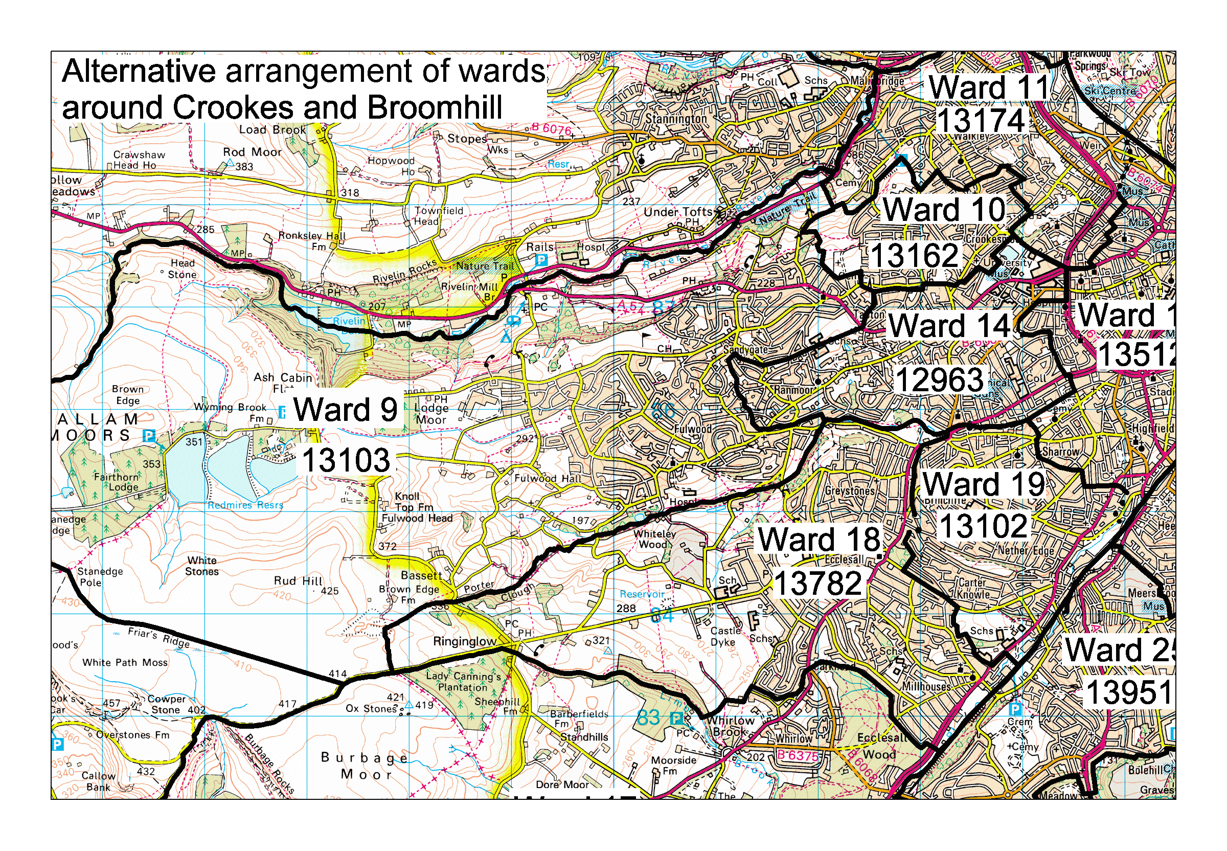
3.1 The PER draft recommends arranging this area into eight new wards, provisionally named Broomhill, Central, Crookes, Ecclesall, Fulwood, Nether Edge, Totley and Dore, and Walkley.
3.2 Across most of this area the proposed wards make a good fit electorally and with the geography. It is unfortunate that the tight figures have ended up with such a strangely-shaped Broomhill ward crushed into the middle.
3.3 The PER draft puts the Commonside area between Ashberry Road, Oxford Road and Barber Road in the proposed Broomhill ward, as per my original submission. While this area is seen as the approach to Walkley from town, it has stronger links with Crookes at the top of Springvale Road than it does with Broomhill. There are no clear communications links from Commonside to Broomhill other than through Crookes or by going towards town and back out again.
3.4 If some adjustments could be made around the proposed Broomhill and Crookes wards to include Commonside in with Crookes, this would result in a better fit of communities. I passed these concerns on to elected members in this area to see if they, with their better street-by-street knowledge of the area, could find some adjustment that would result in a more acceptable arrangement.
3.5 Along the eastern edge of this sector the railway line is used for most of its length as the ward boundaries. However, between Abbey Lane and Twentywell Lane the River Sheaf is used instead for a short length.
3.6 I recommend that the boundary continues to use the easternmost railbed south of Abbey Lane until it crosses the River Sheaf east of Dore Station as the line starts to turn east towards Bradway tunnel. It should then follow the river the few metres until it rejoins the PER draft boundary east of Twentywell Lane, as shown on Map D.
3.7 The boundary between Ecclesall ward and Totley and Dore ward appears to run so as to ensure that the whole of the Abbeydale Industrial Hamlet's head dam is included within one ward. While this makes a strange alignment, I can understand the justification for this, and would recommend that this alignment is used.
3.8 It makes a good arrangement for Ringinglow to be included in the proposed Ecclesall ward. The main communications route from Ringinglow is along Ringinglow Road towards the center of Ecclesall and this ties the village in.
3.9 The boundary between Walkley and Crookes wards follows a footpath through Bole Hill Recreation Ground. This footpath tends to move each winter with the effects of the weather. I recommend following the southern edge of the recreation ground between Tinker Lane and Northfield Avenue, as shown on Map E.
3.10 This boundary then passes through an unnamed road stub between number 114 and 120 Northfield Road. This leaves two houses, numbers 112 and 114, stranded at the southernmost end of the proposed Walkley ward past the Council Works depot and a visual break in the street-scene. This depot has recently closed. If housing is developed on this site its most likely access would be to the north to Eastfield Road. The boundary should pass north of these two houses to include them in the Crookes ward. This is shown on Map E.
5: Boundary to follow railway line south of Abbey Lane, Map D.
6: Boundary between Crookes and Walkley to follow edge of Bole Hill recreation ground, Map E.
7: 112-114 Northfield Road to be in Crookes ward, Map E.
4.1 The PER draft recommends arranging this area into four new wards, provisionally named Arbourthorne and Gleadless, Beauchief and Greenhill, Gleadless Valley and Heeley, Graves Park, and Manor.
4.2 These new wards fit the area electorally and geographically quite well.
4.3 I would recommend that the boundary between Graves Park ward and Gleadless Valley and Heeley ward between Chesterfield Road and Auckley Road continue north from Auckley Road Chesterfield Road, and the south along Chesterfield Road to rejoin the proposed boundary heading east. This has no electoral effect, but provides a stronger line on the ground.
8: Minor realignment near Auckley Road, Map F.
5.1 The PER draft recommends arranging this area into six new wards, provisionally named Beighton and Hackenthorpe, Birley, Darnall, Mosborough, Richmond, and Woodhouse.
5.2 There appears to be full consensus on the proposed Mosborough ward. With minor variations along the edges, everybody ended up drawing the same ward.
5.3 The westernmost boundary of Beighton and Hackenthorpe ward, while leaving Hackenthorpe split, follows a better line than any of the original submissions, and makes for some better electorate numbers.
5.4 In my original submission I tried hard to unify the center of Handsworth in a single ward, with the result that my proposed Darnall strayed outside the hoped-for 5% margin. The proposed Darnall/Woodhouse boundary fits better electorally. It still divides Handsworth itself, but in a less worse way.
5.5 In the west the PER draft recommends a northern Richmond ward and a southern Birley ward, with a boundary following the line of the mostly culverted Shire Brook.
5.6 With the additional electors at the Hackenthorpe end it is possible to reconsider an east-west alignment for these two wards instead of the proposed north-south alignment. I believe that this would give a better grouping of communities on the ground and more clearly defined boundaries. The additional area at the eastern end added on from the Hackenthorpe area counterbalances for the area around Richmond Road from my original submission.
5.7 I recommend using the boundary proposed in my original submission between "Ward 22" and "Ward 26", with the difference that the area between Mansfield Drive, Mansfield Road and Woodhouse road be in the north-eastern ward.
5.8 The recommended boundary would then run as: centre of Birley Moor Road, eastern boundary of properties on Wadsworth Avenue, eastern boundary of properties on Hollybank Drive, southern side of Normanton Hill, line between the Carpenter area and Mansfield Drive, eastern boundary of Intake Cemetery, center of Mansfield Road to City Road.
5.9 Between Ridgeway Road and Mansfield Road the Shire Brook is a barely noticeable feature on the ground. Birley Moor Road and Mansfield Road are major arterial roads. The Base Green area near White Lane spreads across the Shire Brook towards Hollinsend Road. Using the Shire Brook as a boundary at this point would continue to artificially divide a community, when a means to join it together is available.
5.10 Birley Moor Road is a major road and splits the Frecheville area east of the road off from the Birley area west. For most of its length south of Silkstone Road properties do not actually face onto Birley Moor Road, but rather, it is fronted with the rear of properties that face away from it.
5.11 This would result in a rearrangement of the electors in these two wards as shown:
PER Draft Proposal:
2001 2006
Electorate: 4: Birley 13701 +1% 13242 -2%
21: Richmond 13259 -2% 13232 -2%
Recommendation:
2001 2006
Electorate: 4: western ward 13572 +0% 13303 -2%
21: eastern ward 13388 -1% 13171 -3%
9: Swap north-south alignment of Birley and Richmond wards for an east-west alignment.