Summary overview
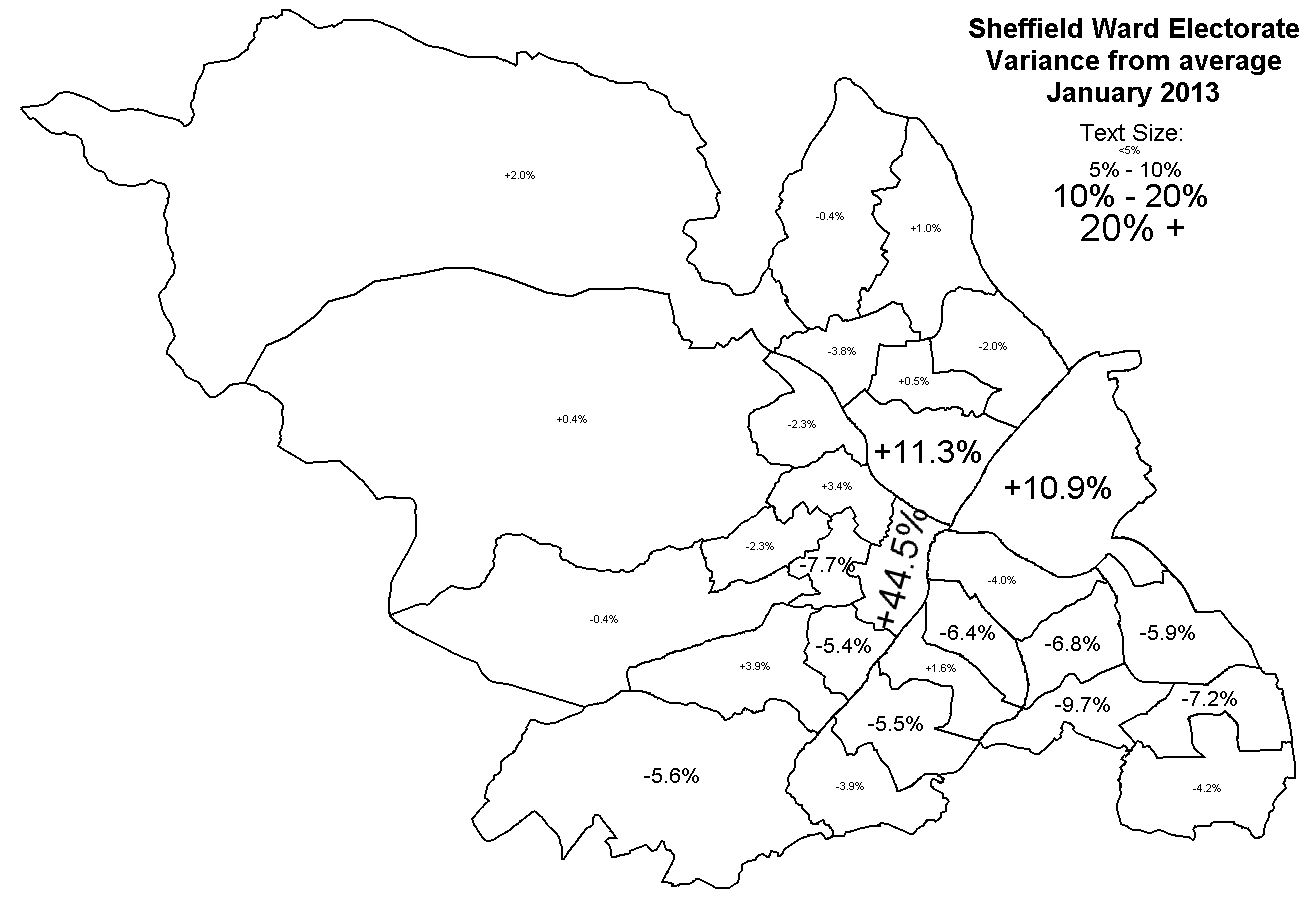
Looking at the Variance map, what is immediately obvious is that almost all of the city is slightly under average - only mathematically possible because of the three wards that are so far above average, Darnall 10.9%, Burngreave 11.3%, Central 44.5%!If the council remains with close to 28 wards then the majority of wards could remain, but it is not possible to avoid wholesale change around the city centre.
The Boundary Commission like minimal changes. In 2002 almost all wards were drastically off from the target (18 out of 28 wards were more than 10% off and 23 were outside 5%, see here), and many boundaries had been arbitarility drawn in the 1980 review, so the best model in 2002 was to wipe everything off the map and start again from scratch. This time, only three wards are off target, and essentially only one ward is the cause for the review. The best acceptable model to the Commission would be something that avoids wholesale change. The 2002 review got very close to successfully grouping together whole communities without splitting them up or grouping them in arbitary collections, and rejoining communities that had been split up. A minimal change model would provide strong continuity with these existing wards.
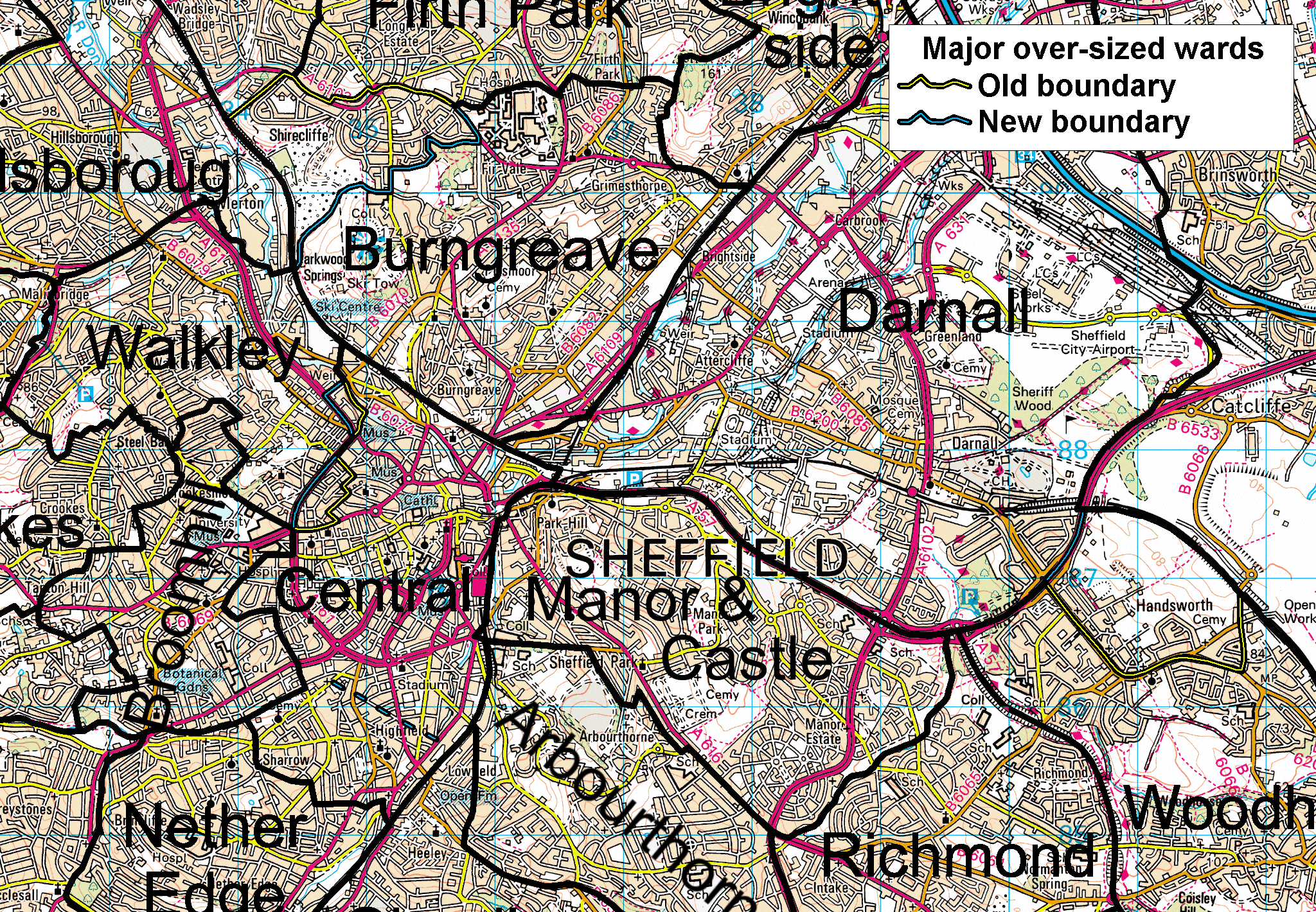
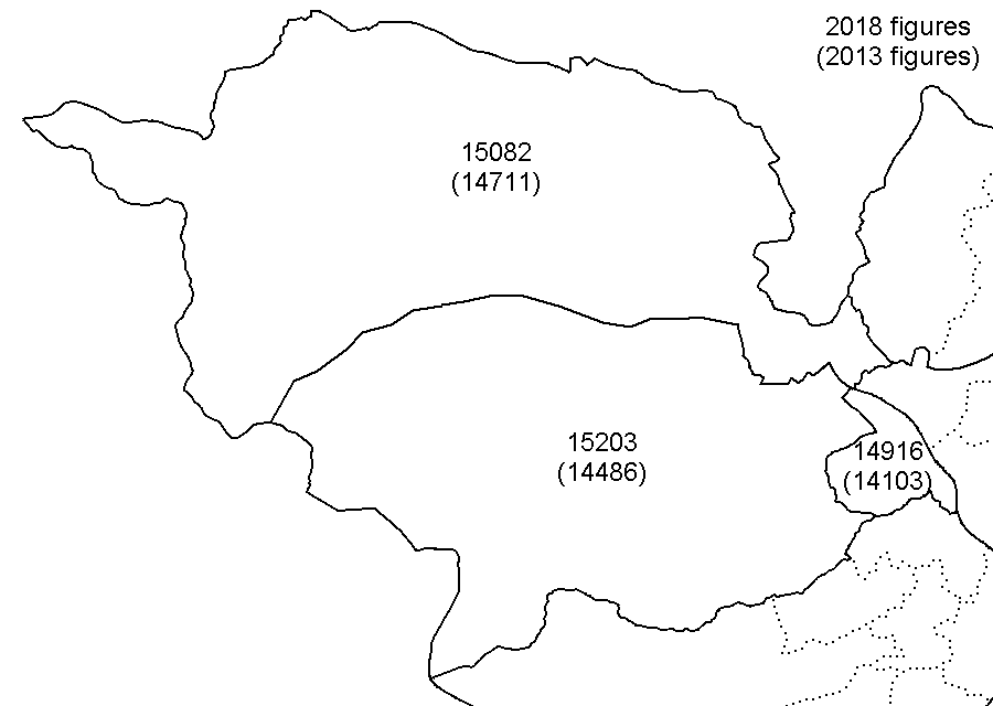
Darnall
Burngreave
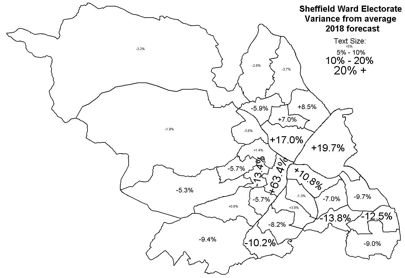
Burngreave was originally too small and had to be expanded in 2002, now it is too big by almost the same amount and needs to be reduced. It can be reduced down to close to the pre-2004 Burngreave by transfering Shirecliffe (FJ and a bit of FH) and Busk Meadow (FB) back out (map), This would drop Burngreave down to about 13,500 in 2013 (down from +11.3% to -7%) and forecast down to about 15,500 in 2013 (down from +17 to -4%).
Central
The current Central ward being +45% top heavy is the biggest problem, and is forecast to get to +63% by 2018. Adding in the area around St. George's Close from Walkley, and transfering the Broomhall (GB) polling district into Broomhill creates a single city centre area consistantly bounded by the railway lines and Inner Ring Road. This City Centre area has a current electorate of about 10,000, and forecast to increase to about 12,500. This would be a consistant area to base a new City Centre ward on, spreading out past the Inner Ring Road to get the additional 4,000 or so additional electors required for 27, 28 or 29 wards. Adding in the Broomhall (GB) and Edmund (GE) polling districts would bring this to about 16,800; or adding Broomhall and the student residences around Boston Street would come to about 16,500.In summary, the following would be the simplest option to implement to deal with these three wards with the greatest electorate discrepancies for any model with 27, 28 or 29 wards (map here):
Each sector would then need adjustments of the remaining wards to tidy them up and take up the slack from repairing the major discrepancies.
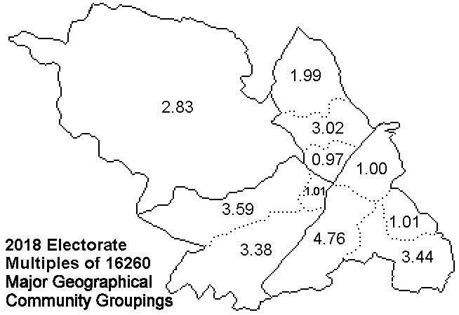
North-West sectorCurrently: 3 wardsThe north-west sector currently has 3 wards, and would be entitled to between 2.8 and 3.1 wards for between 26 and 30 total wards. All three existing wards are within 5% tolerance with the current electorate and with the 2018 forecast. It is possible to push the southern boundary of Hillsborough southwards very slightly from Holme Lane/Bradfield Road to the River Loxley, but no further. The simplest model that would apply for any council size bwteen 26 and 30 wards is to keep the three existing wards. Pushing the southern boundary to the River Loxley would add about 320 electors to Hillsborough if needed. If desired, the two rural 3-member wards could be combined and replaced with three 2-members wards.
| 
|
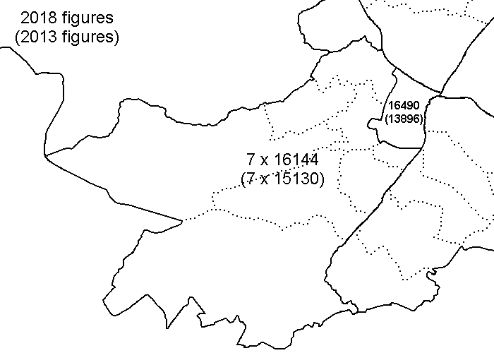
North-East sectorCurrently: 6 wardsThe north-east sector currently has 6 wards, and would be entitled to between 5.9 and 6.1 wards with a full council of between 27 and 28 wards. However, although the sector is entitled to the same number of wards as it currently has, Burngreave ward is 11% too big. Luckily, all the other wards are slightly small, and all but Firth Park are forecast to be drifting smaller by 2018 (see forecast), so everything can be shuffled south to take up the slack. Burngreave can be altered by removing Shirecliffe and Busk Meadow as described above. East and West Ecclesfield are forecast to be about 5%-6% too small, which is simple to rectify by pushing their southern boundary a bit further south towards the pre-1968 Ecclesfield boundary along Tongue Gutter/Sheffield Lane Dyke, taking in more of the remaining bits of Ecclesfield that are not in a ward named Ecclesfield. The northern halves of Mansel (WE) and Parson Cross (WF) polling districts would bring East and West Ecclesfield to about 2.0 wards. If desired, the two rural 3-member wards could be combined and replaced with three 2-members wards. The remaining Southey, Firth Park and Shiregreen & Brightside wards with the bits added in to reduce the size of Burngreave comes to near enough exactly 3.0 wards. Each of the three wards is off from target, Shiregreen & Brightside and Firth Park forecast to be about 7% too big, and Southey about 5% too small, so the three wards need to be shuffled slightly eastwards to redistribute the electorate.
| 
|
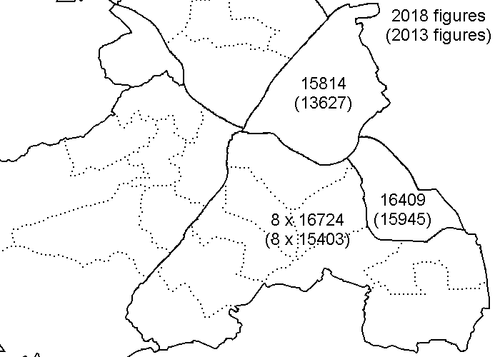
South-East sectorCurrently: 11 wardsThe south-east sector sector currently has 11 wards, and would be entitled to between 9.8 and 10.2 wards with a full council of 26 to 27 wards, or would be entitled to 11 wards with a full council of 29 wards. All the wards are around 5% too small (except Gleadless Valley), except for Darnall which is 11% too big. All the wards other than Darnall and Gleadless Valley are forecast to be around 10% too small by 2018. Darnall and Woodhouse can be brought into target by simply swapping Fitzalan polling district as described above, leaving two wards neatly bound by strong geographic features. The remaining nine wards then need rearranging into eight wards for a 27-ward model, or shuffled around to redistribute the nine wards for a 29-ward model. All the southern wards are too small, and forecast to get even smaller, so they need to get larger geographically; the northern wards are growing so they need to shrink geographically to restore their electorate balance.
| 
|
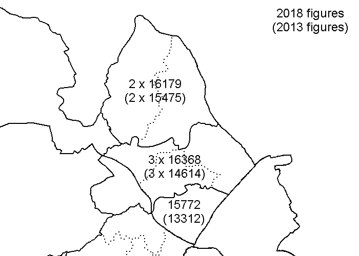
South-West sectorCurrently: 8 wardsThe south-west sector sector currently has 8 wards, and would be entitled to exactly 8 wards with a full council of 27 wards. Any other full council size would result in the south-west sector being entitled to a fractional number of wards. Although almost all the south-west wards are close to the target electorate, it is severly unbalanced by Central ward at +45%, forcast to rise even further to +63%, and the neighbouring Broomhill ward is forecast to continue its shrinkage to -13%. As described above, the area within the Inner Ring Road forms a consistant area with an electorate of about 12,500 than could form the core of a single ward, along with some areas just outside the Inner Ring Road. Adding Central and Broomhill together gives 2.5 wards, so more has to be done than just joining the greated oversized and undersiazed wards together. The area north of the Porter Valley would give 3.6 wards, and the area south 3.4 wards, so the Porter Valley will have to be crossed at some point. The geography constrains this to be nearer the city centre than elsewhere. An option that could be considered is to slice the city centre into two parts so that the northern and southern subsectors contain exactly four wards.
| 
|
HOME DOCUMENTS LINKS RECENT CHANGES
Hosted by Force9 Internet - Authored by J.G.Harston - Last update: 11-May-2013, 24-May-2013, 31-Mar-2014